Site Entry
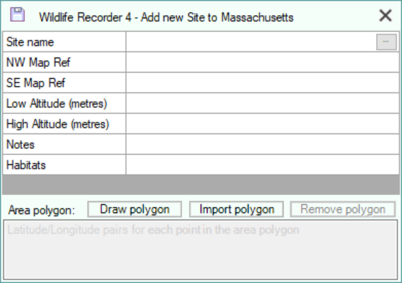
The following information can be entered:
|
Field |
Required |
Permissible values |
|
Site name |
Mandatory |
An alphanumeric string 1 to 75 characters in length. |
|
NW Map Reference |
Optional |
A valid latitude or longitude or UK OS Grid reference for the single point location or the NW corner of an area. The reference may be entered manually (See Rules for entering Map References), or, selected from a map. To select from a map click the button at the right of the cell or press Ctrl+E. (see Setting position from a map) |
|
SE Map Reference |
Optional |
A valid latitude or longitude or UK OS Grid reference for the SE corner of an area. The reference may be entered manually (See Rules for entering Map References), or, selected from a map. To select from a map click the button at the right of the cell or press Ctrl+E. (see Setting position from a map) |
|
Low Altitude |
Optional |
The lowest or single altitude for the location entered in metric or imperial measurements depending on the units you have requested in Preferences. |
|
High Altitude |
Optional |
The highest altitude for the location entered in metric or imperial measurements depending on the units you have requested in Preferences. |
|
Notes |
Optional |
Unlimited text notes about the location. The notes may be entered in the notes cell. If you have long notes to enter a Notes Editor window can be displayed by clicking the button at the right of the cell or pressing Ctrl+E. |
| Habitats | Opitional | You may select one or more habitats from the list of Habitats defined in your database. To select the habitats click the button at the right of the cell or press Ctrl+E. (see selecting Habitats and Habitat Administration) |
Optionally the area of a site can be described as a complex polygon instead of a rectangle defined by the NW/SE corners.
The polygon can be created using Bing Maps or can be imported from a GeoJson or KML file created by an external program. (see Polygon Support for Locations and Lists)
To create a polygon using Bing Maps, click the Draw Polygon button. (see Create a Polygon).
To import a polygon from a GeoJSON or KML file, click the Import Polygon button.
To remove the currently defined polgon, click the Remove Polygon button.
Saving the Site Record
Click the Save button  or press Ctrl+S on the keyboard
Cancelling the changes
To close the form without saving any changes click the close button![]() or press Esc on the keyboard.
or press Esc on the keyboard.